
Thank you for supporting this site ❤️
Make a donation
Make a donation
Gear up for your next adventure:
As an Amazon Associate, this site earns from qualifying purchases at no extra cost to you.
Oksibil topographic map
Click on the map to display elevation.
Thank you for supporting this site ❤️
Make a donation
Make a donation
Gear up for your next adventure:
As an Amazon Associate, this site earns from qualifying purchases at no extra cost to you.
About this map
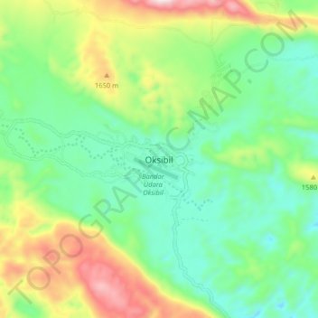
Name: Oksibil topographic map, elevation, terrain.
Location: Oksibil, Pegunungan Bintang, Papua, Indonesia (-4.94503 140.58895 -4.86503 140.66895)
Average elevation: 4,708 ft
Minimum elevation: 3,990 ft
Maximum elevation: 6,171 ft
Thank you for supporting this site ❤️
Make a donation
Make a donation
Gear up for your next adventure:
As an Amazon Associate, this site earns from qualifying purchases at no extra cost to you.