Geolocate

Dearborn County topographic map

Click on the map to display elevation.

About this map

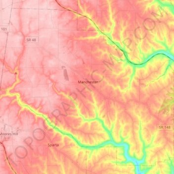
Name: Dearborn County topographic map, elevation, terrain.

Location: Manchester Township, Dearborn County, Indiana, USA (39.08985 -85.09594 39.20618 -84.93032)

Average elevation: 869 ft

Minimum elevation: 482 ft

Maximum elevation: 1,033 ft

Other topographic maps

Click on a map to view its topography, its elevation and its terrain.

Kankakee River

USA > Indiana

Average elevation: 679 ft

Gear up for your next adventure:

👟Men's Trail Runners - Lightweight footwear for fast-paced exploration and light hiking
🔭Compact Binoculars - HD vision for scouting terrain and identifying distant landmarks
🔭Telescopic Hiking Pole - Adjustable pole for hiking stability
🍳Camping Cook Set - Complete cookware for outdoor meals
🪶Wildlife Field Guides - Learn animal tracking and species ID

As an Amazon Associate, this site earns from qualifying purchases at no extra cost to you.