Geolocate

Dasuya topographic map

Click on the map to display elevation.

Dasuya

Dasuya is located in Hoshiarpur district of Punjab state in India. at 31°49′N 75°40′E / 31.82°N 75.66°E / 31.82; 75.66. It has an average elevation of 239 metres (784 ft) from sea level.

Wikipedia (CC-BY-SA 3.0)

About this map

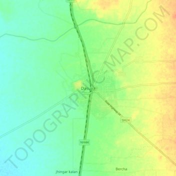
Name: Dasuya topographic map, elevation, terrain.

Location: Dasuya, Dasua Tahsil, Hoshiarpur, Punjab, 144205, India (31.77431 75.61730 31.85431 75.69730)

Average elevation: 833 ft

Minimum elevation: 781 ft

Maximum elevation: 909 ft

Other topographic maps

Click on a map to view its topography, its elevation and its terrain.

Dasua Tahsil

India > Punjab > Dasua Tahsil

Average elevation: 1,014 ft

Gear up for your next adventure:

📡Handheld GPS Device - Reliable handheld GPS for outdoor navigation
🛰️Handheld GPS Units - Professional satellite navigators for precise backcountry mapping
📚Navigation Handbooks - Master the art of reading topographic maps and using a compass
🔭Telescopic Hiking Pole - Adjustable pole for hiking stability
🛠️Outdoor Gear Repair Kit - Essential tools to fix gear on the trail

As an Amazon Associate, this site earns from qualifying purchases at no extra cost to you.