
Make a donation
Gear up for your next adventure:
As an Amazon Associate, this site earns from qualifying purchases at no extra cost to you.
Larderello topographic map
Click on the map to display elevation.
Make a donation
Gear up for your next adventure:
As an Amazon Associate, this site earns from qualifying purchases at no extra cost to you.
Larderello
Il borgo si trova sulle Colline Metallifere a 390 metri di altitudine, conta 900 abitanti ed è in parte proprietà di Enel. Larderello produce il 10% dell'energia geotermica mondiale, con un ammontare di circa 4800 GWh annui, dando energia a un milione di case italiane. Il Guinness dei primati 1988 riportava.
Make a donation
Gear up for your next adventure:
As an Amazon Associate, this site earns from qualifying purchases at no extra cost to you.
About this map
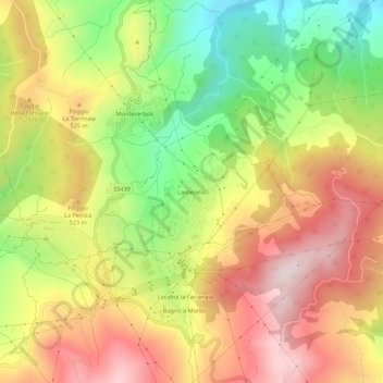
Name: Larderello topographic map, elevation, terrain.
Location: Larderello, Pomarance, Pisa, Toscana, 56041, Italia (43.22003 10.86797 43.26003 10.90797)
Average elevation: 1,509 ft
Minimum elevation: 715 ft
Maximum elevation: 2,234 ft
Make a donation
Gear up for your next adventure:
As an Amazon Associate, this site earns from qualifying purchases at no extra cost to you.