
Make a donation
Gear up for your next adventure:
As an Amazon Associate, this site earns from qualifying purchases at no extra cost to you.
Dudswell topographic map
Click on the map to display elevation.
Make a donation
Gear up for your next adventure:
As an Amazon Associate, this site earns from qualifying purchases at no extra cost to you.
About this map
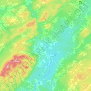
Name: Dudswell topographic map, elevation, terrain.
Location: Dudswell, Le Haut-Saint-François, Estrie, Quebec, Canada (45.50039 -71.71563 45.71285 -71.46211)
Average elevation: 1,014 ft
Minimum elevation: 643 ft
Maximum elevation: 2,087 ft
Make a donation
Gear up for your next adventure:
As an Amazon Associate, this site earns from qualifying purchases at no extra cost to you.
Other topographic maps
Click on a map to view its topography, its elevation and its terrain.
Make a donation
Gear up for your next adventure:
As an Amazon Associate, this site earns from qualifying purchases at no extra cost to you.
Montagne de Franceville
Canada > Quebec > Le Haut-Saint-François > Hampden
Average elevation: 1,972 ft