Geolocate

Stateline topographic map

Click on the map to display elevation.

About this map

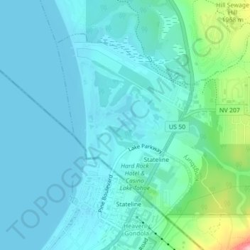
Name: Stateline topographic map, elevation, terrain.

Location: Stateline, Douglas County, Nevada, United States (38.95691 -119.95387 38.97666 -119.93495)

Average elevation: 6,306 ft

Minimum elevation: 6,224 ft

Maximum elevation: 6,736 ft

Douglas County trails, hiking, mountain biking, running and outdoor activities

Gear up for your next adventure:

👟Men's Trail Runners - Lightweight footwear for fast-paced exploration and light hiking
🔪Outdoor Multitools - Essential survival tools for gear repair and field use
🗻Climbing Gear Basics - Essential gear for beginner climbers
🥩Freeze-Dried Meals - Nutritious and lightweight food for remote expeditions
🧭GPS Watch Accessories - Bands and chargers for GPS watches

As an Amazon Associate, this site earns from qualifying purchases at no extra cost to you.