
Make a donation
Gear up for your next adventure:
As an Amazon Associate, this site earns from qualifying purchases at no extra cost to you.
Budadiri topographic map
Click on the map to display elevation.
Make a donation
Gear up for your next adventure:
As an Amazon Associate, this site earns from qualifying purchases at no extra cost to you.
Budadiri
Budadiri is located approximately 15 kilometres (9 mi), by road, southeast of Sironko, where the district headquarters are located. This is approximately 39 kilometres (24 mi), by road, north-east of Mbale, the largest city in the Bugisu sub-region. The geographical coordinates of the town are:01°10'17.0"N, 34°20'06.0"E (Latitude:1.171389; Longitude:34.335000). Budadiri is situated at an average elevation of 1,519 metres (4,984 ft) above sea level.
Make a donation
Gear up for your next adventure:
As an Amazon Associate, this site earns from qualifying purchases at no extra cost to you.
About this map
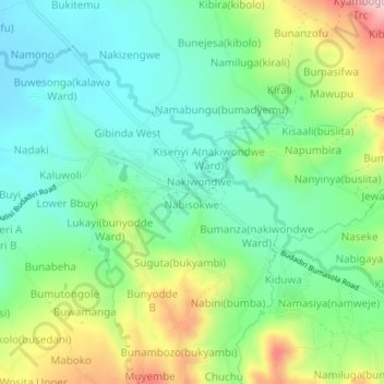
Name: Budadiri topographic map, elevation, terrain.
Location: Budadiri, Bugisa sub-region, Sironko, Eastern Region, Uganda (1.15078 34.31553 1.19078 34.35553)
Average elevation: 4,186 ft
Minimum elevation: 3,871 ft
Maximum elevation: 4,859 ft
Make a donation
Gear up for your next adventure:
As an Amazon Associate, this site earns from qualifying purchases at no extra cost to you.