
Make a donation
Gear up for your next adventure:
As an Amazon Associate, this site earns from qualifying purchases at no extra cost to you.
Ghorahi topographic map
Click on the map to display elevation.
Make a donation
Gear up for your next adventure:
As an Amazon Associate, this site earns from qualifying purchases at no extra cost to you.
Ghorahi
Ghorahi is the main town of the Rapti Zone and also the headquarters of the Dang district. It is located at an elevation of 2,300 feet (700 m) in the Mahabharat-Chure hill region.
Make a donation
Gear up for your next adventure:
As an Amazon Associate, this site earns from qualifying purchases at no extra cost to you.
About this map
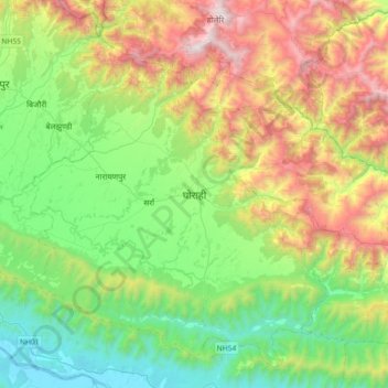
Name: Ghorahi topographic map, elevation, terrain.
Location: Ghorahi, Dang, 22415, Nepal (27.87936 82.32669 28.19936 82.64669)
Average elevation: 2,838 ft
Minimum elevation: 715 ft
Maximum elevation: 7,008 ft
Make a donation
Gear up for your next adventure:
As an Amazon Associate, this site earns from qualifying purchases at no extra cost to you.