
Make a donation
Gear up for your next adventure:
As an Amazon Associate, this site earns from qualifying purchases at no extra cost to you.
Stutensee topographic map
Click on the map to display elevation.
Make a donation
Gear up for your next adventure:
As an Amazon Associate, this site earns from qualifying purchases at no extra cost to you.
Stutensee
The city is situated between Karlsruhe and Bruchsal in the Upper Rhine region and its altitude is 114 m (374 ft).
Make a donation
Gear up for your next adventure:
As an Amazon Associate, this site earns from qualifying purchases at no extra cost to you.
About this map
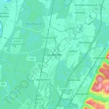
Name: Stutensee topographic map, elevation, terrain.
Average elevation: 387 ft
Minimum elevation: 312 ft
Maximum elevation: 860 ft
Make a donation
Gear up for your next adventure:
As an Amazon Associate, this site earns from qualifying purchases at no extra cost to you.
Other topographic maps
Click on a map to view its topography, its elevation and its terrain.
Dettenheim (Baden)
Germany > Baden-Württemberg > Landkreis Karlsruhe > Dettenheim
Average elevation: 328 ft