
Make a donation
Gear up for your next adventure:
As an Amazon Associate, this site earns from qualifying purchases at no extra cost to you.
Piggott topographic map
Click on the map to display elevation.
Make a donation
Gear up for your next adventure:
As an Amazon Associate, this site earns from qualifying purchases at no extra cost to you.
Piggott
The topography of Piggott is mostly flat in the eastern half of the city with the more developed western half lying along Crowley’s Ridge, creating a sensation of coming down from a small mount to the flatland below. This ridge is a naturally occurring phenomenon created over millennia by wind-blown periglacial loess and possibly by seismic activity in the region.
Make a donation
Gear up for your next adventure:
As an Amazon Associate, this site earns from qualifying purchases at no extra cost to you.
About this map
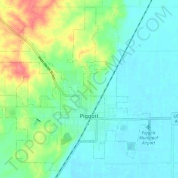
Name: Piggott topographic map, elevation, terrain.
Location: Piggott, Clay County, Arkansas, 72454, United States (36.36471 -90.23803 36.41825 -90.16600)
Average elevation: 338 ft
Minimum elevation: 266 ft
Maximum elevation: 535 ft
Clay County trails, hiking, mountain biking, running and outdoor activities
Make a donation
Gear up for your next adventure:
As an Amazon Associate, this site earns from qualifying purchases at no extra cost to you.
Other topographic maps
Click on a map to view its topography, its elevation and its terrain.