Geolocate

Mompeo topographic map

Click on the map to display elevation.

About this map

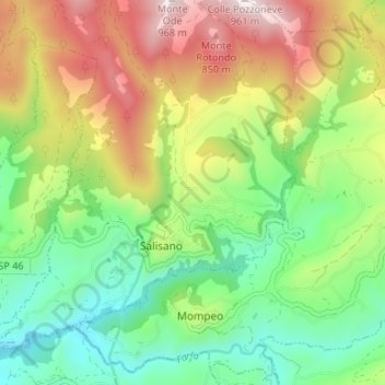
Name: Mompeo topographic map, elevation, terrain.

Location: Mompeo, Rieti, Lazio, Italy (42.24054 12.73018 42.28495 12.79717)

Average elevation: 1,427 ft

Minimum elevation: 381 ft

Maximum elevation: 3,074 ft

Other topographic maps

Click on a map to view its topography, its elevation and its terrain.

Monticchio

Italy > Lazio > Rieti > Monte San Giovanni in Sabina

Average elevation: 2,552 ft

Poggio Corese

Italy > Lazio > Rieti

Average elevation: 1,158 ft

Villanova

Italy > Lazio > Rieti > Accumoli

Average elevation: 3,415 ft

Pian de' Valli

Italy > Lazio > Rieti > Rieti > Pian de' Valli

Average elevation: 5,016 ft

Gear up for your next adventure:

🛠️Backpacking Tool Kit - Essential toolkit for outdoor repairs
🚑Emergency Bivvies - Heat-reflective sleeping bags for survival situations
🪶Camping Sleeping Pad - Comfortable sleeping pad for backpacking
📷Action Cameras - Rugged cameras to document your journeys across rugged terrain
🥾Men's Hiking Boots - Durable, waterproof footwear for rugged terrain and steep inclines

As an Amazon Associate, this site earns from qualifying purchases at no extra cost to you.