
Make a donation
Gear up for your next adventure:
As an Amazon Associate, this site earns from qualifying purchases at no extra cost to you.
Le Rouget topographic map
Click on the map to display elevation.
Make a donation
Gear up for your next adventure:
As an Amazon Associate, this site earns from qualifying purchases at no extra cost to you.
About this map
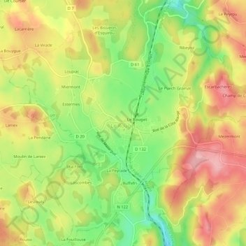
Name: Le Rouget topographic map, elevation, terrain.
Average elevation: 2,005 ft
Minimum elevation: 1,759 ft
Maximum elevation: 2,218 ft
Make a donation
Gear up for your next adventure:
As an Amazon Associate, this site earns from qualifying purchases at no extra cost to you.
Other topographic maps
Click on a map to view its topography, its elevation and its terrain.
Les Troix Croix
France > Auvergne-Rhône-Alpes > Cantal > Le Rouget-Pers > Pers
Average elevation: 1,952 ft
La Bouygue de Lacarriere
France > Auvergne-Rhône-Alpes > Cantal > Le Rouget-Pers > Le Rouget > Loupiac
Average elevation: 2,024 ft
Make a donation
Gear up for your next adventure:
As an Amazon Associate, this site earns from qualifying purchases at no extra cost to you.
Miermont
France > Auvergne-Rhône-Alpes > Cantal > Le Rouget-Pers > Le Rouget
Average elevation: 2,001 ft
La Peyrade
France > Auvergne-Rhône-Alpes > Cantal > Le Rouget-Pers > Le Rouget
Average elevation: 1,998 ft