
Make a donation
Gear up for your next adventure:
As an Amazon Associate, this site earns from qualifying purchases at no extra cost to you.
Lindscheid topographic map
Click on the map to display elevation.
Make a donation
Gear up for your next adventure:
As an Amazon Associate, this site earns from qualifying purchases at no extra cost to you.
Lindscheid
Fachwerkroute: Die zahlreich guterhaltenen und renovierten Fachwerkhäusern sind Gegenstand dieser Tour. Es müssen 8 Höhenunterschiede bewältigt werden.
Make a donation
Gear up for your next adventure:
As an Amazon Associate, this site earns from qualifying purchases at no extra cost to you.
About this map
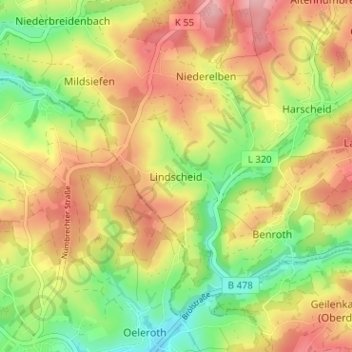
Name: Lindscheid topographic map, elevation, terrain.
Average elevation: 804 ft
Minimum elevation: 577 ft
Maximum elevation: 1,024 ft
Make a donation
Gear up for your next adventure:
As an Amazon Associate, this site earns from qualifying purchases at no extra cost to you.
Other topographic maps
Click on a map to view its topography, its elevation and its terrain.
Kurpark Nümbrecht
Deutschland > Nordrhein-Westfalen > Oberbergischer Kreis > Nümbrecht > Ödinghausen
Average elevation: 919 ft
Schloss Homburg
Deutschland > Nordrhein-Westfalen > Oberbergischer Kreis > Nümbrecht > Homburg-Bröl > Unter der Hardt
Average elevation: 843 ft
Guxmühlen
Deutschland > Nordrhein-Westfalen > Oberbergischer Kreis > Nümbrecht > Marienberghausen
Auf der Hardt | Abbenroth | Ahebruch | Ahlbusch | Alsbach | Altennümbrecht | Bierenbachtal | Breunfeld | Benroth | Berkenroth | Birkenbach | Breitewiese | Brünglinghausen | Bruch | Büschhof | Buch | Distelkamp | Drinsahl | Elsenroth | Erlinghausen | Friedenthal | Gaderoth | Gerhardsiefen | Geringhausen |…
Average elevation: 814 ft