Geolocate

Austerlitz topographic map

Click on the map to display elevation.

About this map

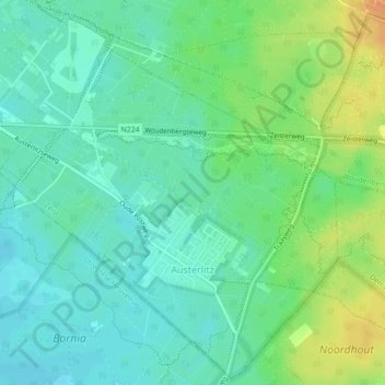
Name: Austerlitz topographic map, elevation, terrain.

Location: Austerlitz, Zeist, Utrecht, Netherlands (52.07033 5.29088 52.09645 5.33262)

Average elevation: 66 ft

Minimum elevation: 26 ft

Maximum elevation: 141 ft

Gear up for your next adventure:

🗃️Trail First Aid Kit - Essential kit for outdoor injuries and emergencies
📌Outdoor GPS Map App - Apps and devices for digital topographic navigation
🛠️Outdoor Gear Repair Kit - Essential tools to fix gear on the trail
🥄Camping Utensil Set - Lightweight utensils for outdoor meals
🔊Portable Camp Speaker - Music and alerts at camp

As an Amazon Associate, this site earns from qualifying purchases at no extra cost to you.