
Make a donation
Gear up for your next adventure:
As an Amazon Associate, this site earns from qualifying purchases at no extra cost to you.
Mount Camiguin topographic map
Click on the map to display elevation.
Make a donation
Gear up for your next adventure:
As an Amazon Associate, this site earns from qualifying purchases at no extra cost to you.
Mount Camiguin
The well-forested Mount Camiguin or Camiguin de Babuyanes has an elevation of 712 metres (2,336 ft) asl, and a base diameter of 3,200 metres (10,500 ft). It occupies the southwest tip of 22 km (14 mi) long Camiguin Island.
Make a donation
Gear up for your next adventure:
As an Amazon Associate, this site earns from qualifying purchases at no extra cost to you.
About this map
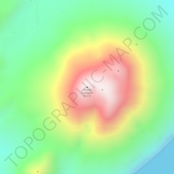
Name: Mount Camiguin topographic map, elevation, terrain.
Average elevation: 945 ft
Minimum elevation: 0 ft
Maximum elevation: 2,244 ft
Make a donation
Gear up for your next adventure:
As an Amazon Associate, this site earns from qualifying purchases at no extra cost to you.