
Entraunes topographic map
Interactive map
Click on the map to display elevation.
Entraunes
The Var has its source in the commune at an elevation of 1790 m at the foot of the Estenc Glacier.
About this map
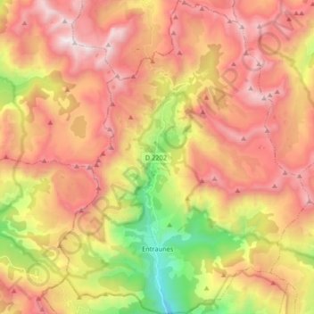
Name: Entraunes topographic map, elevation, terrain.
Average elevation: 7,129 ft
Minimum elevation: 3,678 ft
Maximum elevation: 9,915 ft
Other topographic maps
Click on a map to view its topography, its elevation and its terrain.
Saint Antoine
France > Provence-Alpes-Côte d'Azur > Maritime Alps > Sospel
Average elevation: 1,883 ft
Col de Turini
France > Provence-Alpes-Côte d'Azur > Maritime Alps > Moulinet
Average elevation: 5,082 ft
Sainte-Claire
France > Provence-Alpes-Côte d'Azur > Maritime Alps > Guillaumes
Average elevation: 3,488 ft
La Madone
France > Provence-Alpes-Côte d'Azur > Maritime Alps > Saint-Martin-Vésubie
Average elevation: 3,776 ft
Mont Agel
France > Provence-Alpes-Côte d'Azur > Maritime Alps > Peille
Mont Agel is a mountain on the border between France and Monaco. The summit of this mount, at 1,148 metres (3,766 ft) above sea level, is on the French side, but the highest point of Monaco, lying on a pathway named Chemin des Révoires, is on its slopes, at an altitude of 161 metres (528 feet).
Average elevation: 2,592 ft
Réca Véssas
France > Provence-Alpes-Côte d'Azur > Maritime Alps > Clans > Bancairon
Average elevation: 2,051 ft
Cannes
France > Provence-Alpes-Côte d'Azur > Maritime Alps > Cannes > Cannes
Average elevation: 177 ft
Cime de la Bonette
France > Provence-Alpes-Côte d'Azur > Maritime Alps > Saint-Dalmas-le-Selvage
Average elevation: 8,241 ft