Geolocate

Jacob City topographic map

Click on the map to display elevation.

About this map

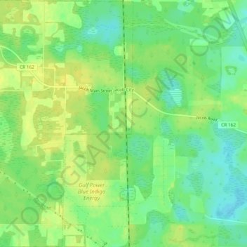
Name: Jacob City topographic map, elevation, terrain.

Location: Jacob City, Jackson County, Florida, United States (30.86917 -85.42205 30.90940 -85.39590)

Average elevation: 141 ft

Minimum elevation: 102 ft

Maximum elevation: 174 ft

Jackson County trails, hiking, mountain biking, running and outdoor activities

Other topographic maps

Click on a map to view its topography, its elevation and its terrain.

Two Egg

United States > Florida > Jackson County

Average elevation: 128 ft

Shady Grove

United States > Florida > Jackson County

Average elevation: 161 ft

Compass Lake

United States > Florida > Jackson County

Average elevation: 217 ft

Drummond Bay

United States > Florida > Jackson County

Average elevation: 138 ft

Graceville

United States > Florida > Jackson County > Graceville

Average elevation: 167 ft

Alford

United States > Florida > Jackson County > Alford

Average elevation: 141 ft

Gear up for your next adventure:

🧥Men's Rain Shells - Premium waterproof and breathable jackets for mountain weather
🗃️Trail First Aid Kit - Essential kit for outdoor injuries and emergencies
🧣Merino Neck Gaiters - Multi-functional headwear for wind and sun protection
💧Water Purification System - Clean water on the trail with reliable purifiers
🛠️Outdoor Gear Repair Kit - Essential tools to fix gear on the trail

As an Amazon Associate, this site earns from qualifying purchases at no extra cost to you.