Geolocate

Toano topographic map

Click on the map to display elevation.

About this map

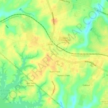
Name: Toano topographic map, elevation, terrain.

Location: Toano, James City County, Virginia, 23168, United States (37.35987 -76.82413 37.39987 -76.78413)

Average elevation: 89 ft

Minimum elevation: 26 ft

Maximum elevation: 131 ft

James City County trails, hiking, mountain biking, running and outdoor activities

Other topographic maps

Click on a map to view its topography, its elevation and its terrain.

Gear up for your next adventure:

📡GPS Antenna Upgrade - Enhance GPS reception in remote terrain
🧭Map Reading Tools - Tools and kits for map navigation
💧Water Purification System - Clean water on the trail with reliable purifiers
📷Action Cameras - Rugged cameras to document your journeys across rugged terrain
🔭Compact Binoculars - HD vision for scouting terrain and identifying distant landmarks

As an Amazon Associate, this site earns from qualifying purchases at no extra cost to you.