Kennewick topographic map
Click on the map to display elevation.
Kennewick
Native Americans populated the area around modern-day Kennewick for millennia before being discovered and settled by European descendants. These inhabitants consisted of people from the Umatilla, Wanapum, Nez Perce, and Yakama tribes. Kennewick's low elevation helped to moderate winter temperatures. On top of this, the riverside location made salmon and other river fish easily accessible. By the 19th century, people lived in and between two major camps in the area. These were located near present-day Sacajawea State Park in Pasco and Columbia Point in Richland. Lewis and Clark noted that there were many people living in the area when they passed through in 1805 and 1806. The map produced following their journey marks two significant villages in the area - Wollawollah and Selloatpallah. These had approximate populations of 2,600 and 3,000 respectively.
About this map
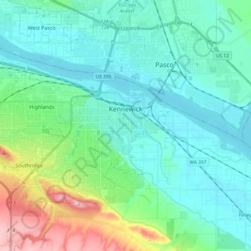
Name: Kennewick topographic map, elevation, terrain.
Location: Kennewick, Benton County, Washington, United States (46.15440 -119.26685 46.24054 -119.08721)
Average elevation: 515 ft
Minimum elevation: 328 ft
Maximum elevation: 1,188 ft
Benton County trails, hiking, mountain biking, running and outdoor activities
Other topographic maps
Click on a map to view its topography, its elevation and its terrain.

Vista
United States > Washington > Benton County > Kennewick
Native Americans populated the area around modern-day Kennewick for millennia before being discovered and settled by European descendants. These inhabitants consisted of people from the Umatilla, Wanapum, Nez Perce, and Yakama tribes. Kennewick's low elevation helped to moderate winter temperatures. On top of…
Average elevation: 558 ft