Geolocate

Alta topographic map

Click on the map to display elevation.

Alta

Alta is located just east of the Idaho state line, approximately 5 miles (8 km) east of Driggs, at an elevation of 6,440 feet (1,963 m) above sea level.

Wikipedia (CC-BY-SA 3.0)

About this map

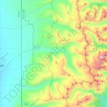
Name: Alta topographic map, elevation, terrain.

Location: Alta, Teton County, Wyoming, United States (43.63222 -111.04673 43.86506 -110.82401)

Average elevation: 8,127 ft

Minimum elevation: 6,086 ft

Maximum elevation: 13,681 ft

Teton County trails, hiking, mountain biking, running and outdoor activities

Other topographic maps

Click on a map to view its topography, its elevation and its terrain.

Lewis Lake

United States > Wyoming > Teton County

Average elevation: 7,874 ft

Delta Lake

United States > Wyoming > Teton County

Average elevation: 9,242 ft

Moran

United States > Wyoming > Teton County

Average elevation: 6,850 ft

Kelly

United States > Wyoming > Teton County

Average elevation: 6,762 ft

Yosemite Point

United States > Wyoming > Teton County

Average elevation: 9,232 ft

Beaver Creek

United States > Wyoming > Teton County

Average elevation: 6,703 ft

Bobcat Ridge

United States > Wyoming > Teton County

Average elevation: 9,032 ft

Moose

United States > Wyoming > Teton County

Average elevation: 6,598 ft

Gear up for your next adventure:

🗃️Trail First Aid Kit - Essential kit for outdoor injuries and emergencies
🌲Outdoor Survival Books - Best books on survival skills
🛰️Satellite Messengers - Emergency SOS and two-way messaging for off-grid adventures
💧Water Purification System - Clean water on the trail with reliable purifiers
📶Satellite Messenger - Communication device off‑grid

As an Amazon Associate, this site earns from qualifying purchases at no extra cost to you.