Geolocate

Dalton topographic map

Click on the map to display elevation.

About this map
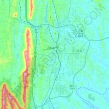
Name: Dalton topographic map, elevation, terrain.

Location: Dalton, Whitfield County, Georgia, United States (34.69987 -85.03963 34.82026 -84.85948)

Average elevation: 833 ft

Minimum elevation: 636 ft

Maximum elevation: 1,791 ft

Whitfield County trails, hiking, mountain biking, running and outdoor activities

Other topographic maps

Click on a map to view its topography, its elevation and its terrain.
Rocky Face

United States > Georgia > Whitfield County

Average elevation: 912 ft

Mount Rachel

United States > Georgia > Whitfield County > Dalton

Average elevation: 755 ft

Beaverdale

United States > Georgia > Whitfield County

Average elevation: 758 ft

Gear up for your next adventure:

👟Men's Trail Runners - Lightweight footwear for fast-paced exploration and light hiking
🪶Camp Gear Gift Set - Perfect gift bundle for outdoor fans
🌧️Backpack Rain Cover - Keep gear dry in wet weather
🧣Merino Neck Gaiters - Multi-functional headwear for wind and sun protection
🔥Fast-Boil Camping Stoves - Efficient cooking systems for quick trail meals

As an Amazon Associate, this site earns from qualifying purchases at no extra cost to you.