
Flurstück Anhausen topographic map
Interactive map
Click on the map to display elevation.
About this map
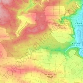
Name: Flurstück Anhausen topographic map, elevation, terrain.
Average elevation: 1,837 ft
Minimum elevation: 1,549 ft
Maximum elevation: 2,041 ft
Other topographic maps
Click on a map to view its topography, its elevation and its terrain.
Ugenhof
Deutschland > Baden-Württemberg > Landkreis Heidenheim > Herbrechtingen
Ugenhof, Flurstück Bolheim, Gemarkung Bolheim, Herbrechtingen, Landkreis Heidenheim, Baden-Württemberg, 89542, Deutschland
Average elevation: 1,903 ft
Gemarkung Bolheim
Deutschland > Baden-Württemberg > Landkreis Heidenheim > Herbrechtingen
Gemarkung Bolheim, Herbrechtingen, Landkreis Heidenheim, Baden-Württemberg, Deutschland
Average elevation: 1,785 ft