
Make a donation
Gear up for your next adventure:
As an Amazon Associate, this site earns from qualifying purchases at no extra cost to you.
Ugenhof topographic map
Click on the map to display elevation.
Make a donation
Gear up for your next adventure:
As an Amazon Associate, this site earns from qualifying purchases at no extra cost to you.
About this map
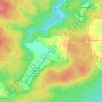
Name: Ugenhof topographic map, elevation, terrain.
Average elevation: 1,903 ft
Minimum elevation: 1,768 ft
Maximum elevation: 2,034 ft
Make a donation
Gear up for your next adventure:
As an Amazon Associate, this site earns from qualifying purchases at no extra cost to you.
Other topographic maps
Click on a map to view its topography, its elevation and its terrain.
Flurstück Anhausen
Deutschland > Baden-Württemberg > Landkreis Heidenheim > Herbrechtingen
Average elevation: 1,837 ft
Lixenfeld
Deutschland > Baden-Württemberg > Landkreis Heidenheim > Herbrechtingen
Average elevation: 1,903 ft
Bolheim
Deutschland > Baden-Württemberg > Landkreis Heidenheim > Herbrechtingen
Average elevation: 1,798 ft
89542
Deutschland > Baden-Württemberg > Landkreis Heidenheim > Herbrechtingen > Bolheim
Average elevation: 1,752 ft
Make a donation
Gear up for your next adventure:
As an Amazon Associate, this site earns from qualifying purchases at no extra cost to you.
Eselsburger Tal
Deutschland > Baden-Württemberg > Landkreis Heidenheim > Herbrechtingen > Anhausen
Average elevation: 1,677 ft
Hausen ob Lontal
Deutschland > Baden-Württemberg > Landkreis Heidenheim > Herbrechtingen
Average elevation: 1,745 ft