Gunlock topographic map
Interactive map
Click on the map to display elevation.
About this map
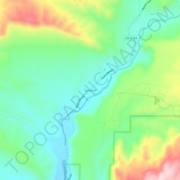
Name: Gunlock topographic map, elevation, terrain.
Location: Gunlock, Washington County, Utah, 84733, United States (37.26609 -113.78330 37.30609 -113.74330)
Average elevation: 3,970 ft
Minimum elevation: 3,579 ft
Maximum elevation: 4,780 ft
The community lies on the Santa Clara River, northwest of the Red Mountains along local roads, northwest of the city of St. George, the county seat of Washington County. Its elevation is 3,658 feet (1,115 m). Although Gunlock is unincorporated, it has a post office, with the ZIP code of 84733.
Other topographic maps
Click on a map to view its topography, its elevation and its terrain.
Saint George
United States > Utah > Washington County
Saint George, Washington County, Utah, United States
Average elevation: 3,048 ft
Zion National Park
United States > Utah > Washington County
Zion National Park, Washington County, Utah, United States
Average elevation: 6,158 ft
Pine Valley
United States > Utah > Washington County
Pine Valley, Washington County, Utah, 84781, United States
Average elevation: 6,864 ft
Dammeron Valley
United States > Utah > Washington County
Dammeron Valley, Washington County, Utah, 84783, United States
Average elevation: 4,738 ft
Sand Mountain
United States > Utah > Washington County
Sand Mountain, Washington County, Utah, United States
Average elevation: 3,904 ft
Toquerville
United States > Utah > Washington County
Toquerville, Washington County, Utah, 84774, United States
Average elevation: 4,268 ft
Hildale
United States > Utah > Washington County
Hildale, Washington County, Utah, 84784, United States
Average elevation: 5,784 ft
Snow Canyon State Park
United States > Utah > Washington County
Snow Canyon State Park, Washington County, Utah, 84738, United States
Average elevation: 3,835 ft
Pintura
United States > Utah > Washington County
Pintura, Washington County, Utah, United States
Average elevation: 4,534 ft
Silver Reef
United States > Utah > Washington County > Leeds
Silver Reef, Leeds, Washington County, Utah, 84746, United States
Average elevation: 3,888 ft
Bee Hive
United States > Utah > Washington County
Bee Hive, Washington County, Utah, 84767, United States
Average elevation: 5,417 ft
Kolob Reservoir
United States > Utah > Washington County
Kolob Reservoir, Washington County, Utah, United States
Average elevation: 8,199 ft
Washington
United States > Utah > Washington County
Washington, Washington County, Utah, 84780, United States
Average elevation: 3,031 ft
Virgin
United States > Utah > Washington County > Virgin
Virgin, Washington County, Utah, United States
Average elevation: 4,104 ft
Mount Baldy
United States > Utah > Washington County
Mount Baldy, Washington County, Utah, United States
Average elevation: 7,717 ft
Zion Lodge
United States > Utah > Washington County
Zion Lodge, Washington County, Utah, United States
Average elevation: 5,650 ft
Hurricane Hill
United States > Utah > Washington County > Hurricane
Hurricane Hill, Hurricane, Washington County, Utah, 84745, United States
Average elevation: 3,524 ft
New Harmony
United States > Utah > Washington County > New Harmony
New Harmony, Washington County, Utah, United States
Average elevation: 5,367 ft
Hurricane
United States > Utah > Washington County
Hurricane, Washington County, Utah, United States
Average elevation: 3,786 ft
Pine Valley
United States > Utah > Washington County > Pine Valley
Pine Valley, Washington County, Utah, 84781, United States
Average elevation: 6,808 ft
Springdale
United States > Utah > Washington County
Springdale, Washington County, Utah, 84767, United States
Average elevation: 4,426 ft
Bloomington Hill
United States > Utah > Washington County > St. George
Bloomington Hill, St. George, Washington County, Utah, 84770-1858, United States
Average elevation: 2,657 ft
Hurricane
United States > Utah > Washington County > Hurricane > Hurricane
Hurricane, Washington County, Utah, 84745, United States
Average elevation: 3,527 ft
Central
United States > Utah > Washington County > Central
Central, Washington County, Utah, 84722, United States
Average elevation: 5,367 ft
Watchman Trailhead
United States > Utah > Washington County > Springdale
Watchman Trailhead, Springdale, Washington County, Utah, 84767, United States
Average elevation: 4,318 ft
Enterprise
United States > Utah > Washington County
Enterprise, Washington County, Utah, 84725, United States
Average elevation: 5,545 ft
Ivins
United States > Utah > Washington County
Ivins, Washington County, Utah, 84738, United States
Average elevation: 3,304 ft
La Verkin
United States > Utah > Washington County
La Verkin, Washington County, Utah, United States
Average elevation: 3,665 ft
Veyo
United States > Utah > Washington County
Veyo, Washington County, Utah, 84782, United States
Average elevation: 4,524 ft