
Make a donation
Gear up for your next adventure:
As an Amazon Associate, this site earns from qualifying purchases at no extra cost to you.
New London topographic map
Click on the map to display elevation.
Make a donation
Gear up for your next adventure:
As an Amazon Associate, this site earns from qualifying purchases at no extra cost to you.
About this map
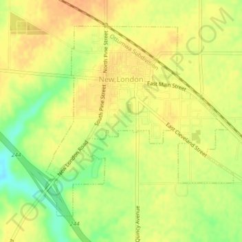
Name: New London topographic map, elevation, terrain.
Location: New London, Henry County, Iowa, United States (40.91069 -91.41394 40.93194 -91.38622)
Average elevation: 758 ft
Minimum elevation: 682 ft
Maximum elevation: 794 ft
Henry County trails, hiking, mountain biking, running and outdoor activities
Make a donation
Gear up for your next adventure:
As an Amazon Associate, this site earns from qualifying purchases at no extra cost to you.
Other topographic maps
Click on a map to view its topography, its elevation and its terrain.
Mount Pleasant
United States > Iowa > Henry County > Mount Pleasant > Mount Pleasant
The Mount Pleasant Municipal Airport (FAA Identifier: MPZ) is at an elevation of 730 ft (222.5 m) and is located 3 miles (4.8 km) southeast of the city. The airport started operations in March 1945. As of May 2014 it has 2 runways: Runway 15/33 is hard surfaced (asphalt) and is 4001 ft long × 75 ft wide (1220…
Average elevation: 702 ft