
Thank you for supporting this site ❤️
Make a donation
Make a donation
Gear up for your next adventure:
As an Amazon Associate, this site earns from qualifying purchases at no extra cost to you.
Droeshout topographic map
Click on the map to display elevation.
Thank you for supporting this site ❤️
Make a donation
Make a donation
Gear up for your next adventure:
As an Amazon Associate, this site earns from qualifying purchases at no extra cost to you.
About this map
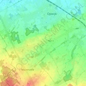
Name: Droeshout topographic map, elevation, terrain.
Average elevation: 108 ft
Minimum elevation: 36 ft
Maximum elevation: 230 ft
Thank you for supporting this site ❤️
Make a donation
Make a donation
Gear up for your next adventure:
As an Amazon Associate, this site earns from qualifying purchases at no extra cost to you.
Other topographic maps
Click on a map to view its topography, its elevation and its terrain.
Mazenzele
België > Vlaams-Brabant > Halle-Vilvoorde > Opwijk
De bodem van Mazenzele bestaat uit zand en leem. Het landschap is heuvelachtig en de hoogte varieert van 35-68 meter.
Average elevation: 164 ft