Geolocate

Dutch Harbor topographic map

Click on the map to display elevation.

About this map

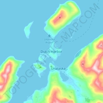
Name: Dutch Harbor topographic map, elevation, terrain.

Location: Dutch Harbor, Unalaska, Aleutians West Census Area, Alaska, 99692, United States (53.84675 -166.58180 53.92675 -166.50180)

Average elevation: 279 ft

Minimum elevation: -13 ft

Maximum elevation: 1,923 ft

Aleutians West Census Area trails, hiking, mountain biking, running and outdoor activities

Gear up for your next adventure:

🛌Ultralight Sleeping Bags - Compact down bags for cold nights in the wilderness
🧭Orienteering Set - Complete compass and map reading kit
🥾Hiking Shoes - Durable and comfortable shoes for trail hiking
🌡️Handheld Weather Meters - Measure wind, temp, and pressure for safe mountain travel
GPS Sports Watch - GPS watch for running, hiking and training

As an Amazon Associate, this site earns from qualifying purchases at no extra cost to you.