Geolocate

Myrtle Point topographic map

Click on the map to display elevation.

About this map

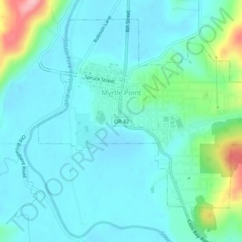
Name: Myrtle Point topographic map, elevation, terrain.

Location: Myrtle Point, Coos County, Oregon, United States (43.04822 -124.15269 43.07222 -124.11378)

Average elevation: 108 ft

Minimum elevation: 3 ft

Maximum elevation: 561 ft

Coos County trails, hiking, mountain biking, running and outdoor activities

Other topographic maps

Click on a map to view its topography, its elevation and its terrain.

Englewood

United States > Oregon > Coos County > Coos Bay

Average elevation: 135 ft

Sitkum

United States > Oregon > Coos County

Average elevation: 1,102 ft

Charleston

United States > Oregon > Coos County

Average elevation: 79 ft

Bullards

United States > Oregon > Coos County

Average elevation: 30 ft

Randolph

United States > Oregon > Coos County

Average elevation: 118 ft

Sitkum

United States > Oregon > Coos County

Average elevation: 1,102 ft

Lampa Mountain

United States > Oregon > Coos County

Average elevation: 358 ft

Whiskey Run Beach

United States > Oregon > Coos County

Average elevation: 72 ft

Gear up for your next adventure:

🧦Merino Wool Socks - Moisture-wicking, blister-preventing socks for long treks
🎒Outdoor Daypacks - Lightweight backpacks designed for carrying maps and essential gear
🌐World Map Poster - Decorative world maps with topographic info
😴Insulated Sleeping Pads - Compact and warm pads for high-elevation camping
🥤Water Filter Bottle - All‑in‑one filter bottle for safe hydration

As an Amazon Associate, this site earns from qualifying purchases at no extra cost to you.