
Thank you for supporting this site ❤️
Make a donation
Make a donation
Gear up for your next adventure:
As an Amazon Associate, this site earns from qualifying purchases at no extra cost to you.
Hinterstoder topographic map
Click on the map to display elevation.
Thank you for supporting this site ❤️
Make a donation
Make a donation
Gear up for your next adventure:
As an Amazon Associate, this site earns from qualifying purchases at no extra cost to you.
About this map
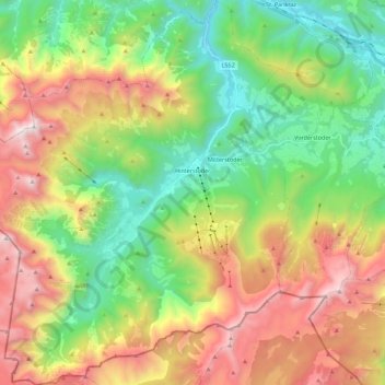
Name: Hinterstoder topographic map, elevation, terrain.
Location: Hinterstoder, Bezirk Kirchdorf, 4573, Austria (47.61590 14.01060 47.76613 14.21258)
Average elevation: 4,209 ft
Minimum elevation: 1,591 ft
Maximum elevation: 8,205 ft
Thank you for supporting this site ❤️
Make a donation
Make a donation
Gear up for your next adventure:
As an Amazon Associate, this site earns from qualifying purchases at no extra cost to you.