
Make a donation
Gear up for your next adventure:
As an Amazon Associate, this site earns from qualifying purchases at no extra cost to you.
Thoreau topographic map
Click on the map to display elevation.
Make a donation
Gear up for your next adventure:
As an Amazon Associate, this site earns from qualifying purchases at no extra cost to you.
Thoreau
Thoreau is located at an altitude of approximately 2,200 meters (7,200 feet) above sea level, and 8 kilometers (5.0 mi) east of the continental divide. Thoreau is located in a broad valley beneath a large escarpment of Entrada sandstone, which marks the southern boundary of the Colorado Plateau to the north. Mount Powell and Castle Rock are landmarks along this escarpment adjacent to Thoreau. The Zuñi Mountains are to the south.
Make a donation
Gear up for your next adventure:
As an Amazon Associate, this site earns from qualifying purchases at no extra cost to you.
About this map
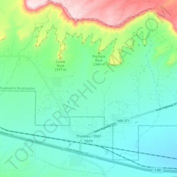
Name: Thoreau topographic map, elevation, terrain.
Location: Thoreau, McKinley County, New Mexico, 87323, United States (35.38735 -108.27384 35.45973 -108.18253)
Average elevation: 7,392 ft
Minimum elevation: 7,014 ft
Maximum elevation: 8,501 ft
McKinley County trails, hiking, mountain biking, running and outdoor activities
Make a donation
Gear up for your next adventure:
As an Amazon Associate, this site earns from qualifying purchases at no extra cost to you.
Other topographic maps
Click on a map to view its topography, its elevation and its terrain.
Make a donation
Gear up for your next adventure:
As an Amazon Associate, this site earns from qualifying purchases at no extra cost to you.
Standing Rock
United States > New Mexico > McKinley County > Standing Rock
Average elevation: 6,335 ft
Pueblo Pintado
United States > New Mexico > McKinley County > Pueblo Pintado
Average elevation: 6,499 ft
Make a donation
Gear up for your next adventure:
As an Amazon Associate, this site earns from qualifying purchases at no extra cost to you.