
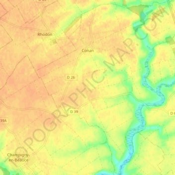
Conan topographic map
Interactive map
Click on the map to display elevation.
About this map
Name: Conan topographic map, elevation, terrain.
Average elevation: 394 ft
Minimum elevation: 318 ft
Maximum elevation: 423 ft
Other topographic maps
Click on a map to view its topography, its elevation and its terrain.
La Pente de l'Aigri
France > Centre-Val de Loire > Loir-et-Cher > Saint-Georges-sur-Cher
La Pente de l'Aigri, Saint-Georges-sur-Cher, Romorantin-Lanthenay, Loir-et-Cher, Centre-Val de Loire, Metropolitan France, 41400, France
Average elevation: 325 ft
Danzé
France > Centre-Val de Loire > Loir-et-Cher
Danzé, Vendôme, Loir-et-Cher, Centre-Val de Loire, Metropolitan France, 41160, France
Average elevation: 495 ft
Souvigny-en-Sologne
France > Centre-Val de Loire > Loir-et-Cher
Souvigny-en-Sologne, Romorantin-Lanthenay, Loir-et-Cher, Centre-Val de Loire, Metropolitan France, 41600, France
Average elevation: 449 ft
Ternay
France > Centre-Val de Loire > Loir-et-Cher
Ternay, Vendôme, Loir-et-Cher, Centre-Val de Loire, Metropolitan France, 41800, France
Average elevation: 325 ft
Lamotte-Beuvron
France > Centre-Val de Loire > Loir-et-Cher
Lamotte-Beuvron, Romorantin-Lanthenay, Loir-et-Cher, Centre-Val de Loire, Metropolitan France, 41600, France
Average elevation: 410 ft
Faubourg Saint-Lubin
France > Centre-Val de Loire > Loir-et-Cher > Vendôme
Faubourg Saint-Lubin, Vendôme-Quartiers Centre, Vendôme, Loir-et-Cher, Centre-Val de Loire, Metropolitan France, 41100, France
Average elevation: 341 ft
La Batardière
France > Centre-Val de Loire > Loir-et-Cher > Montrichard Val de Cher
La Batardière, Bourré, Montrichard Val de Cher, Romorantin-Lanthenay, Loir-et-Cher, Centre-Val de Loire, Metropolitan France, 41400, France
Average elevation: 325 ft
Bourré
France > Centre-Val de Loire > Loir-et-Cher > Montrichard Val de Cher
Bourré, Montrichard Val de Cher, Romorantin-Lanthenay, Loir-et-Cher, Centre-Val de Loire, Metropolitan France, 41400, France
Average elevation: 354 ft
Crouy-sur-Cosson
France > Centre-Val de Loire > Loir-et-Cher
Crouy-sur-Cosson, Blois, Loir-et-Cher, Centre-Val de Loire, Metropolitan France, 41220, France
Average elevation: 315 ft
Chouzy
France > Centre-Val de Loire > Loir-et-Cher > La Chapelle-Saint-Martin-en-Plaine
Chouzy, La Chapelle-Saint-Martin-en-Plaine, Blois, Loir-et-Cher, Centre-Val de Loire, Metropolitan France, 41500, France
Average elevation: 377 ft
Vouzon
France > Centre-Val de Loire > Loir-et-Cher
Vouzon, Romorantin-Lanthenay, Loir-et-Cher, Centre-Val de Loire, Metropolitan France, 41600, France
Average elevation: 413 ft
Le Bourg
France > Centre-Val de Loire > Loir-et-Cher > Chaumont-sur-Tharonne
Le Bourg, Chaumont-sur-Tharonne, Romorantin-Lanthenay, Loir-et-Cher, Centre-Val de Loire, Metropolitan France, 41600, France
Average elevation: 400 ft
Morée
France > Centre-Val de Loire > Loir-et-Cher
Morée, Vendôme, Loir-et-Cher, Centre-Val de Loire, Metropolitan France, 41160, France
Average elevation: 413 ft
Couëtron-au-Perche
France > Centre-Val de Loire > Loir-et-Cher
Couëtron-au-Perche, Vendôme, Loir-et-Cher, Centre-Val de Loire, Metropolitan France, 41170, France
Average elevation: 577 ft
Blois
France > Centre-Val de Loire > Loir-et-Cher
Blois, Loir-et-Cher, Centre-Val de Loire, Metropolitan France, 41000, France
Average elevation: 312 ft