Geolocate

Calusco d'Adda topographic map

Click on the map to display elevation.

About this map

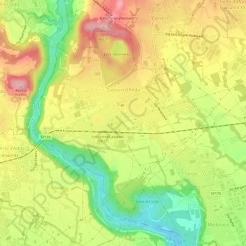
Name: Calusco d'Adda topographic map, elevation, terrain.

Location: Calusco d'Adda, Bergamo, Lombardy, 24033, Italy (45.66923 9.45127 45.70208 9.51165)

Average elevation: 843 ft

Minimum elevation: 505 ft

Maximum elevation: 1,168 ft

Other topographic maps

Click on a map to view its topography, its elevation and its terrain.

Serta

Italy > Lombardy > Bergamo > Schilpario

Average elevation: 4,678 ft

Agro

Italy > Lombardy > Bergamo

Average elevation: 3,031 ft

Gear up for your next adventure:

⛑️Personal Locator Beacon - Safety beacon for emergencies
🧢Sun Protection Hats - Wide-brimmed and UPF-rated hats for high-altitude sun safety
🧯Emergency Survival Kit - All‑in‑one survival essentials for the backcountry
🗺️NatGeo Topo Maps - High-quality waterproof printed topographic maps of US Parks
🧭Pro Hiking Compasses - High-accuracy liquid-filled compasses for topographic orientation

As an Amazon Associate, this site earns from qualifying purchases at no extra cost to you.