Geolocate

Utica topographic map

Click on the map to display elevation.

About this map

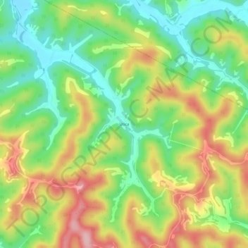
Name: Utica topographic map, elevation, terrain.

Location: Utica, Jackson County, West Virginia, United States (39.02536 -81.67874 39.06536 -81.63874)

Average elevation: 840 ft

Minimum elevation: 604 ft

Maximum elevation: 1,138 ft

Jackson County trails, hiking, mountain biking, running and outdoor activities

Other topographic maps

Click on a map to view its topography, its elevation and its terrain.

Ripley

United States > West Virginia > Jackson County

Average elevation: 705 ft

Gear up for your next adventure:

🪶Trail Camera - Capture wildlife on your hikes
🛡️Bear Spray Outdoor - Protection in bear country hikes
🧣Hiking Neck Gaiter - Multi‑use neck protection for outdoor weather
🥇GPS Hiking Watch - Multi‑sport GPS watch with navigation and trail tracking
🛠️Outdoor Gear Repair Kit - Essential tools to fix gear on the trail

As an Amazon Associate, this site earns from qualifying purchases at no extra cost to you.