
Make a donation
Gear up for your next adventure:
As an Amazon Associate, this site earns from qualifying purchases at no extra cost to you.
Ahorntal topographic map
Click on the map to display elevation.
Make a donation
Gear up for your next adventure:
As an Amazon Associate, this site earns from qualifying purchases at no extra cost to you.
About this map
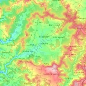
Name: Ahorntal topographic map, elevation, terrain.
Location: Ahorntal, Landkreis Bayreuth, Bavaria, 95491, Germany (49.80253 11.34269 49.87843 11.48680)
Average elevation: 1,529 ft
Minimum elevation: 1,165 ft
Maximum elevation: 2,018 ft
Make a donation
Gear up for your next adventure:
As an Amazon Associate, this site earns from qualifying purchases at no extra cost to you.
Other topographic maps
Click on a map to view its topography, its elevation and its terrain.
Drosendorf an der Aufseß
Germany > Bavaria > Landkreis Bayreuth > Hollfeld
Average elevation: 1,460 ft
Bad Berneck
Germany > Bavaria > Landkreis Bayreuth > Bad Berneck im Fichtelgebirge
Average elevation: 1,555 ft
Make a donation
Gear up for your next adventure:
As an Amazon Associate, this site earns from qualifying purchases at no extra cost to you.
Make a donation
Gear up for your next adventure:
As an Amazon Associate, this site earns from qualifying purchases at no extra cost to you.