Geolocate

Leon topographic map

Click on the map to display elevation.

About this map

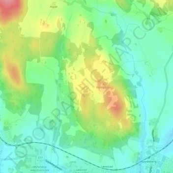
Name: Leon topographic map, elevation, terrain.

Location: Leon, Fjellstad, Indre Østfold, Østfold, 1820, Norway (59.62191 11.05011 59.64191 11.07011)

Average elevation: 440 ft

Minimum elevation: 328 ft

Maximum elevation: 646 ft

Other topographic maps

Click on a map to view its topography, its elevation and its terrain.

Fredrikstad

Norway > Østfold

Average elevation: 49 ft

Ullerøy leirskole

Norway > Østfold > Ullerøy

Average elevation: 46 ft

Skiptvet

Norway > Østfold

Average elevation: 381 ft

Moss

Norway > Østfold

Average elevation: 75 ft

Ertevannet

Norway > Østfold

Average elevation: 404 ft

Knivsøya

Norway > Østfold > Isebakke

Average elevation: 112 ft

Kinnekulle

Norway > Østfold

Average elevation: 486 ft

Halden

Norway > Østfold

Average elevation: 410 ft

Moss

Norway > Østfold

Average elevation: 75 ft

Fredrikstad

Norway > Østfold

Average elevation: 49 ft

Gear up for your next adventure:

📻Weather Alert Radios - Stay informed of storm risks while off-the-grid
🥩Freeze-Dried Meals - Nutritious and lightweight food for remote expeditions
🧺Microfiber Travel Towels - Compact and fast-drying towels for trail use
🧢Sun Protection Hats - Wide-brimmed and UPF-rated hats for high-altitude sun safety
🌄Hiking Binoculars - Compact binoculars for scenic views and trail spotting

As an Amazon Associate, this site earns from qualifying purchases at no extra cost to you.