
Yangon topographic map
Interactive map
Click on the map to display elevation.
About this map
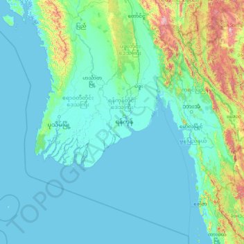
Name: Yangon topographic map, elevation, terrain.
Location: Yangon, Myanmar (14.08757 93.55292 19.20757 98.67292)
Average elevation: 505 ft
Minimum elevation: -10 ft
Maximum elevation: 8,255 ft
Other topographic maps
Click on a map to view its topography, its elevation and its terrain.
North Okkalapa
North Okkalapa, Yangon East, Yangon, Myanmar
Average elevation: 33 ft
Mingaladon
Mingaladon, Yangon, Yangon North, Yangon, Myanmar
Average elevation: 33 ft
Northern District
Northern District, Yangon, Myanmar
Average elevation: 26 ft