
Thank you for supporting this site ❤️
Make a donation
Make a donation
Gear up for your next adventure:
As an Amazon Associate, this site earns from qualifying purchases at no extra cost to you.
Casnate topographic map
Click on the map to display elevation.
Thank you for supporting this site ❤️
Make a donation
Make a donation
Gear up for your next adventure:
As an Amazon Associate, this site earns from qualifying purchases at no extra cost to you.
About this map
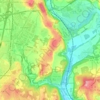
Name: Casnate topographic map, elevation, terrain.
Location: Casnate, Casnate con Bernate, Como, Lombardia, 22073, Italia (45.73603 9.05289 45.77603 9.09289)
Average elevation: 1,004 ft
Minimum elevation: 843 ft
Maximum elevation: 1,211 ft
Thank you for supporting this site ❤️
Make a donation
Make a donation
Gear up for your next adventure:
As an Amazon Associate, this site earns from qualifying purchases at no extra cost to you.