
Make a donation
Gear up for your next adventure:
As an Amazon Associate, this site earns from qualifying purchases at no extra cost to you.
Rickenbach topographic map
Click on the map to display elevation.
Make a donation
Gear up for your next adventure:
As an Amazon Associate, this site earns from qualifying purchases at no extra cost to you.
About this map
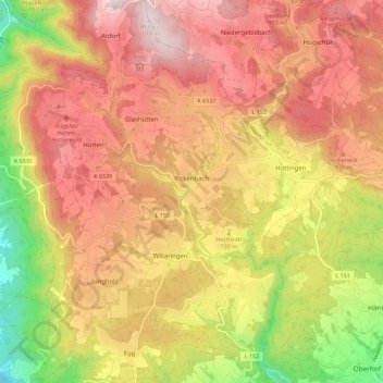
Name: Rickenbach topographic map, elevation, terrain.
Average elevation: 2,402 ft
Minimum elevation: 1,086 ft
Maximum elevation: 3,366 ft
Make a donation
Gear up for your next adventure:
As an Amazon Associate, this site earns from qualifying purchases at no extra cost to you.
Other topographic maps
Click on a map to view its topography, its elevation and its terrain.
Großherrischwand
Germany > Baden-Württemberg > Landkreis Waldshut > Herrischried
Average elevation: 3,018 ft
Hauenstein
Germany > Baden-Württemberg > Landkreis Waldshut > Laufenburg (Baden) > Luttingen
Average elevation: 1,257 ft
Make a donation
Gear up for your next adventure:
As an Amazon Associate, this site earns from qualifying purchases at no extra cost to you.
Niedergebisbach
Germany > Baden-Württemberg > Landkreis Waldshut > Niedergebisbach
Average elevation: 2,861 ft