Geolocate

Polloc topographic map

Click on the map to display elevation.

About this map

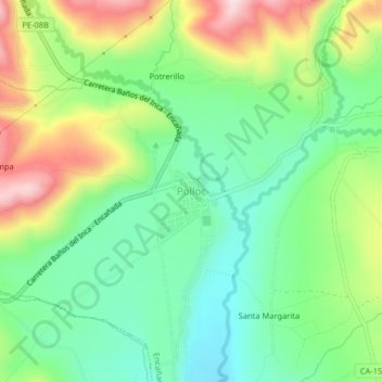
Name: Polloc topographic map, elevation, terrain.

Location: Polloc, Encañada, Cajamarca, Perú (-7.13615 -78.34656 -7.09615 -78.30656)

Average elevation: 9,928 ft

Minimum elevation: 9,554 ft

Maximum elevation: 10,564 ft

Other topographic maps

Click on a map to view its topography, its elevation and its terrain.

Río De La Encañada

Perú > Cajamarca > Encañada > Polloc

Average elevation: 10,810 ft

Laguna Azul

Perú > Cajamarca > Encañada

Average elevation: 13,202 ft

Gear up for your next adventure:

🧤Tactile Hiking Gloves - Keep hands warm while operating GPS and smartphone screens
🪶Fire Starter Kit - Reliable fire starter for survival and camping
🗃️Trail First Aid Kit - Essential kit for outdoor injuries and emergencies
🔦Compact Flashlight - Reliable flashlight for emergencies
🪶Thermal Camp Blanket - Extra warmth for cold nights

As an Amazon Associate, this site earns from qualifying purchases at no extra cost to you.