
Make a donation
Gear up for your next adventure:
As an Amazon Associate, this site earns from qualifying purchases at no extra cost to you.
Cubagua Island topographic map
Click on the map to display elevation.
Make a donation
Gear up for your next adventure:
As an Amazon Associate, this site earns from qualifying purchases at no extra cost to you.
Cubagua Island
The island is 9.2 by 3.6 km (5.7 by 2.2 mi) in size, an elliptical shape with the longer axis east-west. Its area is 22.438 km2 (9 sq mi). The coast consists of some beaches as well as cliffs from 5 to 7 metres (16 to 23 ft) high in the south and from 20 to 24 metres (66 to 79 ft) high in the north. The highest elevation of the flat-topped island reaches 32 metres (105 ft).
Make a donation
Gear up for your next adventure:
As an Amazon Associate, this site earns from qualifying purchases at no extra cost to you.
About this map
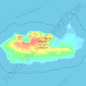
Name: Cubagua Island topographic map, elevation, terrain.
Average elevation: 20 ft
Minimum elevation: -7 ft
Maximum elevation: 184 ft
Make a donation
Gear up for your next adventure:
As an Amazon Associate, this site earns from qualifying purchases at no extra cost to you.
Other topographic maps
Click on a map to view its topography, its elevation and its terrain.