
Thank you for supporting this site ❤️
Make a donation
Make a donation
Gear up for your next adventure:
As an Amazon Associate, this site earns from qualifying purchases at no extra cost to you.
Lunz am See topographic map
Click on the map to display elevation.
Thank you for supporting this site ❤️
Make a donation
Make a donation
Gear up for your next adventure:
As an Amazon Associate, this site earns from qualifying purchases at no extra cost to you.
About this map
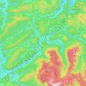
Name: Lunz am See topographic map, elevation, terrain.
Location: Lunz am See, Bezirk Scheibbs, Lower Austria, 3293, Austria (47.78559 14.93222 47.91917 15.10992)
Average elevation: 2,933 ft
Minimum elevation: 1,499 ft
Maximum elevation: 6,102 ft
Thank you for supporting this site ❤️
Make a donation
Make a donation
Gear up for your next adventure:
As an Amazon Associate, this site earns from qualifying purchases at no extra cost to you.
Other topographic maps
Click on a map to view its topography, its elevation and its terrain.
Weissee
Austria > Lower Austria > Bezirk Scheibbs > Gemeinde Oberndorf an der Melk > Weissee
Average elevation: 1,181 ft