
Woodall topographic map
Interactive map
Click on the map to display elevation.
About this map
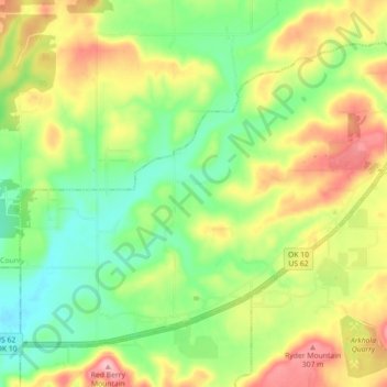
Name: Woodall topographic map, elevation, terrain.
Location: Woodall, Cherokee County, Oklahoma, United States of America (35.79817 -95.12726 35.85501 -95.03807)
Average elevation: 761 ft
Minimum elevation: 558 ft
Maximum elevation: 1,033 ft
Other topographic maps
Click on a map to view its topography, its elevation and its terrain.
Skiatook Lake
United States of America > Oklahoma > Morgans Corner
Skiatook Lake, Major General Clarence L. Tinker Memorial Highway, Morgans Corner, Osage County, Oklahoma, United States of America
Average elevation: 748 ft
Porum
United States of America > Oklahoma > Porum
Porum, Muskogee County, Oklahoma, 74455, United States of America
Average elevation: 594 ft
Idabel
United States of America > Oklahoma > Idabel
Idabel, McCurtain County, Oklahoma, 74745, United States of America
Average elevation: 433 ft
Guymon
United States of America > Oklahoma > Guymon
Guymon, Texas, Oklahoma, United States of America
Average elevation: 3,061 ft
Coalgate
United States of America > Oklahoma > Coalgate
Coalgate, Coal County, Oklahoma, 74538, United States of America
Average elevation: 610 ft
Greer County
United States of America > Oklahoma
Greer County, Oklahoma, United States of America
Average elevation: 1,654 ft
Foss
United States of America > Oklahoma > Foss
Foss, Washita County, Oklahoma, United States of America
Average elevation: 1,667 ft
Wynnewood
United States of America > Oklahoma > Wynnewood
Wynnewood, Oklahoma, 73098, United States of America
Average elevation: 889 ft
Bethany
United States of America > Oklahoma > Bethany
Bethany, Oklahoma County, Oklahoma, United States of America
Average elevation: 1,299 ft