
Make a donation
Gear up for your next adventure:
As an Amazon Associate, this site earns from qualifying purchases at no extra cost to you.
Dullstroom topographic map
Click on the map to display elevation.
Make a donation
Gear up for your next adventure:
As an Amazon Associate, this site earns from qualifying purchases at no extra cost to you.
Dullstroom
Due to its high elevation (Dullstroom being the highest town in South Africa itself), Dullstroom has a subtropical highland climate (Köppen: Cwb). From October to April, the town sees a significant amount of rainfall (higher than nearby Johannesburg to the west), in contrast with winter, where precipitation lacks.
Make a donation
Gear up for your next adventure:
As an Amazon Associate, this site earns from qualifying purchases at no extra cost to you.
About this map
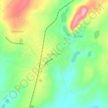
Name: Dullstroom topographic map, elevation, terrain.
Average elevation: 6,591 ft
Minimum elevation: 6,362 ft
Maximum elevation: 6,929 ft
Make a donation
Gear up for your next adventure:
As an Amazon Associate, this site earns from qualifying purchases at no extra cost to you.
Other topographic maps
Click on a map to view its topography, its elevation and its terrain.
Emgwenya (Waterval Boven)
South Africa > Mpumalanga > Nkangala > Emakhazeni Local Municipality
Average elevation: 4,672 ft
Emakhazeni Local Municipality
South Africa > Mpumalanga > Nkangala > Emakhazeni Local Municipality
Average elevation: 5,180 ft