
Make a donation
Gear up for your next adventure:
As an Amazon Associate, this site earns from qualifying purchases at no extra cost to you.
Emgwenya (Waterval Boven) topographic map
Click on the map to display elevation.
Make a donation
Gear up for your next adventure:
As an Amazon Associate, this site earns from qualifying purchases at no extra cost to you.
About this map
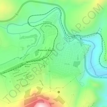
Name: Emgwenya (Waterval Boven) topographic map, elevation, terrain.
Average elevation: 4,672 ft
Minimum elevation: 4,124 ft
Maximum elevation: 5,617 ft
Make a donation
Gear up for your next adventure:
As an Amazon Associate, this site earns from qualifying purchases at no extra cost to you.
Other topographic maps
Click on a map to view its topography, its elevation and its terrain.
Dullstroom
South Africa > Mpumalanga > Nkangala > Emakhazeni Local Municipality
Due to its high elevation (Dullstroom being the highest town in South Africa itself), Dullstroom has a subtropical highland climate (Köppen: Cwb). From October to April, the town sees a significant amount of rainfall (higher than nearby Johannesburg to the west), in contrast with winter, where precipitation…
Average elevation: 6,591 ft
Waterval Boven
South Africa > Mpumalanga > Nkangala > Emakhazeni Local Municipality
Average elevation: 5,075 ft
Machadodorp
South Africa > Mpumalanga > Nkangala > Emakhazeni Local Municipality
Average elevation: 5,220 ft
Machadodorp
South Africa > Mpumalanga > Nkangala > Emakhazeni Local Municipality
Average elevation: 5,220 ft
Make a donation
Gear up for your next adventure:
As an Amazon Associate, this site earns from qualifying purchases at no extra cost to you.
eMakhazeni (Belfast)
South Africa > Mpumalanga > Nkangala > Emakhazeni Local Municipality
Average elevation: 6,201 ft
Dullstroom
South Africa > Mpumalanga > Nkangala > Emakhazeni Local Municipality
Due to its high elevation (Dullstroom being the highest town in South Africa itself), Dullstroom has a subtropical highland climate (Köppen: Cwb). From October to April, the town sees a significant amount of rainfall (higher than nearby Johannesburg to the west), in contrast with winter, where precipitation…
Average elevation: 6,591 ft
Make a donation
Gear up for your next adventure:
As an Amazon Associate, this site earns from qualifying purchases at no extra cost to you.
Machadodorp
South Africa > Mpumalanga > Nkangala > Emakhazeni Local Municipality
Average elevation: 5,220 ft
eMakhazeni (Belfast)
South Africa > Mpumalanga > Nkangala > Emakhazeni Local Municipality
Average elevation: 6,201 ft
Dullstroom
South Africa > Mpumalanga > Nkangala > Emakhazeni Local Municipality
Due to its high elevation (Dullstroom being the highest town in South Africa itself), Dullstroom has a subtropical highland climate (Köppen: Cwb). From October to April, the town sees a significant amount of rainfall (higher than nearby Johannesburg to the west), in contrast with winter, where precipitation…
Average elevation: 6,591 ft
Waterval Boven
South Africa > Mpumalanga > Nkangala > Emakhazeni Local Municipality
Average elevation: 5,075 ft
Make a donation
Gear up for your next adventure:
As an Amazon Associate, this site earns from qualifying purchases at no extra cost to you.
Emakhazeni Local Municipality
South Africa > Mpumalanga > Nkangala > Emakhazeni Local Municipality
Average elevation: 5,180 ft