
Suatisi topographic map
Click on the map to display elevation.
About this map
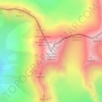
Name: Suatisi topographic map, elevation, terrain.
Location: Suatisi, Kazbegi Municipality, Mtskheta-Mtianeti, Georgia (42.70431 44.39251 42.70441 44.39261)
Average elevation: 12,680 ft
Minimum elevation: 10,673 ft
Maximum elevation: 14,541 ft
Other topographic maps
Click on a map to view its topography, its elevation and its terrain.
Stepantsminda
Georgia > Mtskheta-Mtianeti > Kazbegi Municipality
The town is located along the banks of the Terek River, 157 kilometers (98 mi) to the north of Tbilisi at an elevation of 1,740 meters (5,710 feet) above sea level. Stepantsminda’s climate is moderately humid with relatively dry, cold winters and long and cool summers. The average annual temperature is 4.9…
Average elevation: 6,073 ft
Gergeti Glacier
Georgia > Mtskheta-Mtianeti > Kazbegi Municipality
Gergeti (Georgian: გერგეთი; also known as Ortsveri) is a glacier located on the southeastern slope of Mt. Kazbek in the Kazbegi District of Georgia. The length of the Gergeti glacier is 7.1 km (4.4 mi) and its surface area is 11 km2 (4.2 sq mi). The tongue of Gergeti descends to 2,900 metres…
Average elevation: 13,153 ft
Stepantsminda
Georgia > Mtskheta-Mtianeti > Kazbegi Municipality
The town is located along the banks of the Terek River, 157 kilometers (98 mi) to the north of Tbilisi at an elevation of 1,740 meters (5,710 feet) above sea level. Stepantsminda’s climate is moderately humid with relatively dry, cold winters and long and cool summers. The average annual temperature is 4.9…
Average elevation: 6,073 ft