
Thank you for supporting this site ❤️
Make a donation
Make a donation
Gear up for your next adventure:
As an Amazon Associate, this site earns from qualifying purchases at no extra cost to you.
Chengue topographic map
Click on the map to display elevation.
Thank you for supporting this site ❤️
Make a donation
Make a donation
Gear up for your next adventure:
As an Amazon Associate, this site earns from qualifying purchases at no extra cost to you.
About this map
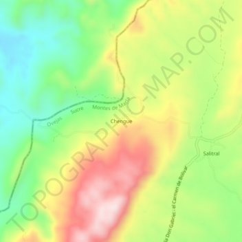
Name: Chengue topographic map, elevation, terrain.
Location: Chengue, Ovejas, Montes de María, Sucre, RAP Caribe, Colombia (9.63207 -75.32012 9.67207 -75.28012)
Average elevation: 1,125 ft
Minimum elevation: 535 ft
Maximum elevation: 1,844 ft
Thank you for supporting this site ❤️
Make a donation
Make a donation
Gear up for your next adventure:
As an Amazon Associate, this site earns from qualifying purchases at no extra cost to you.