Geolocate

Tompo topographic map

Click on the map to display elevation.

About this map

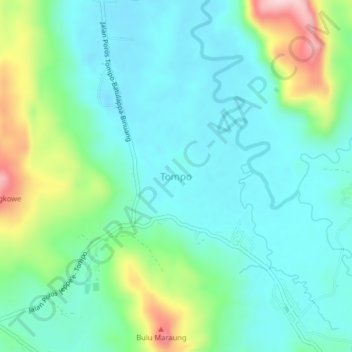
Name: Tompo topographic map, elevation, terrain.

Location: Tompo, Barru, South Sulawesi, Sulawesi, 90711, Indonesia (-4.41232 119.66857 -4.37232 119.70857)

Average elevation: 259 ft

Minimum elevation: 46 ft

Maximum elevation: 896 ft

Gear up for your next adventure:

🧭Compass with Lanyard - Easy‑carry compass for navigation
🛰️Satellite Messengers - Emergency SOS and two-way messaging for off-grid adventures
🔌Solar Panel Charger - Charge gear sustainably outdoors
🧢Sun Protection Hats - Wide-brimmed and UPF-rated hats for high-altitude sun safety
🪑Portable Camp Table - Compact table for campsite meals

As an Amazon Associate, this site earns from qualifying purchases at no extra cost to you.