
Make a donation
Gear up for your next adventure:
As an Amazon Associate, this site earns from qualifying purchases at no extra cost to you.
Dahl topographic map
Click on the map to display elevation.
Make a donation
Gear up for your next adventure:
As an Amazon Associate, this site earns from qualifying purchases at no extra cost to you.
Dahl
Kultureller Höhepunkt von Dahl-Friedrichsthal ist das Schützenfest zu Pfingsten.
Make a donation
Gear up for your next adventure:
As an Amazon Associate, this site earns from qualifying purchases at no extra cost to you.
About this map
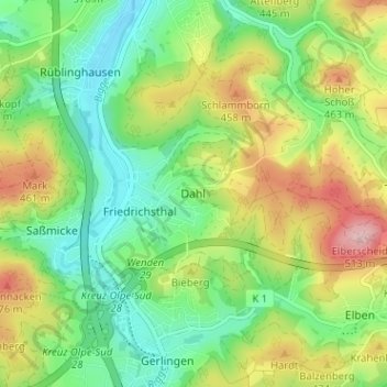
Name: Dahl topographic map, elevation, terrain.
Location: Dahl, Olpe, Kreis Olpe, Nordrhein-Westfalen, 57462, Deutschland (50.98223 7.83166 51.02223 7.87166)
Average elevation: 1,280 ft
Minimum elevation: 1,030 ft
Maximum elevation: 1,693 ft
Make a donation
Gear up for your next adventure:
As an Amazon Associate, this site earns from qualifying purchases at no extra cost to you.
Other topographic maps
Click on a map to view its topography, its elevation and its terrain.