
Make a donation
Gear up for your next adventure:
As an Amazon Associate, this site earns from qualifying purchases at no extra cost to you.
New Holland topographic map
Click on the map to display elevation.
Make a donation
Gear up for your next adventure:
As an Amazon Associate, this site earns from qualifying purchases at no extra cost to you.
About this map
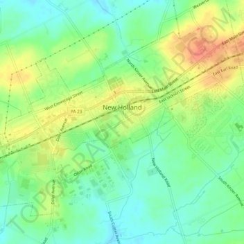
Name: New Holland topographic map, elevation, terrain.
Average elevation: 472 ft
Minimum elevation: 404 ft
Maximum elevation: 564 ft
Lancaster County trails, hiking, mountain biking, running and outdoor activities
Make a donation
Gear up for your next adventure:
As an Amazon Associate, this site earns from qualifying purchases at no extra cost to you.
Other topographic maps
Click on a map to view its topography, its elevation and its terrain.
Reinholds
United States > Pennsylvania > Lancaster County > West Cocalico Township
Average elevation: 522 ft
Welsh Mountain Nature Preserve
United States > Pennsylvania > Lancaster County > East Earl Township
Average elevation: 965 ft
Intercourse
United States > Pennsylvania > Lancaster County > Leacock Township
Average elevation: 417 ft
Make a donation
Gear up for your next adventure:
As an Amazon Associate, this site earns from qualifying purchases at no extra cost to you.
Narvon
United States > Pennsylvania > Lancaster County > Caernarvon Township
Average elevation: 751 ft
Stevens
United States > Pennsylvania > Lancaster County > West Cocalico Township
Average elevation: 397 ft
Make a donation
Gear up for your next adventure:
As an Amazon Associate, this site earns from qualifying purchases at no extra cost to you.
Locust Grove
United States > Pennsylvania > Lancaster County > Conoy Township
Average elevation: 315 ft
Smithville
United States > Pennsylvania > Lancaster County > Providence Township
Average elevation: 459 ft
Make a donation
Gear up for your next adventure:
As an Amazon Associate, this site earns from qualifying purchases at no extra cost to you.
Drumore Center
United States > Pennsylvania > Lancaster County > Drumore Township
Average elevation: 574 ft
Brownstown
United States > Pennsylvania > Lancaster County > West Earl Township
Average elevation: 335 ft
Hopeland
United States > Pennsylvania > Lancaster County > Clay Township > Clay
Average elevation: 509 ft
Welsh Mountain
United States > Pennsylvania > Lancaster County > Caernarvon Township
Average elevation: 764 ft
Make a donation
Gear up for your next adventure:
As an Amazon Associate, this site earns from qualifying purchases at no extra cost to you.
Brooklawn
United States > Pennsylvania > Lancaster County > Manheim Township > Neffsville
Average elevation: 381 ft
Baumgardner
United States > Pennsylvania > Lancaster County > Pequea Township
Average elevation: 413 ft
Coopersville
United States > Pennsylvania > Lancaster County > Sadsbury Township
Average elevation: 600 ft
Churchtown
United States > Pennsylvania > Lancaster County > Caernarvon Township
Average elevation: 535 ft
Make a donation
Gear up for your next adventure:
As an Amazon Associate, this site earns from qualifying purchases at no extra cost to you.
Safe Harbor
United States > Pennsylvania > Lancaster County > Conestoga Township
Average elevation: 338 ft
Stevens
United States > Pennsylvania > Lancaster County > West Cocalico Township
Average elevation: 397 ft
Smithville
United States > Pennsylvania > Lancaster County > Providence Township
Average elevation: 459 ft
Greenland
United States > Pennsylvania > Lancaster County > East Lampeter Township
Average elevation: 367 ft
Make a donation
Gear up for your next adventure:
As an Amazon Associate, this site earns from qualifying purchases at no extra cost to you.
Farmdale
United States > Pennsylvania > Lancaster County > West Hempfield Township
Average elevation: 430 ft
McGovernsville
United States > Pennsylvania > Lancaster County > East Hempfield Township > Rohrerstown
Average elevation: 358 ft
Bowling Green
United States > Pennsylvania > Lancaster County > Manor Township
Average elevation: 351 ft
Make a donation
Gear up for your next adventure:
As an Amazon Associate, this site earns from qualifying purchases at no extra cost to you.
Chestnut Ridge
United States > Pennsylvania > Lancaster County > Rohrerstown > Chestnut Ridge
Average elevation: 400 ft
Reinholds
United States > Pennsylvania > Lancaster County > West Cocalico Township
Average elevation: 522 ft
Make a donation
Gear up for your next adventure:
As an Amazon Associate, this site earns from qualifying purchases at no extra cost to you.