Geolocate

Kanab topographic map

Click on the map to display elevation.

About this map

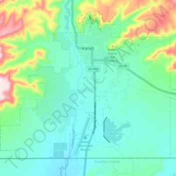
Name: Kanab topographic map, elevation, terrain.

Location: Kanab, Kane County, Utah, United States (37.00068 -112.57594 37.06119 -112.48112)

Average elevation: 5,135 ft

Minimum elevation: 4,757 ft

Maximum elevation: 6,280 ft

Kane County trails, hiking, mountain biking, running and outdoor activities

Other topographic maps

Click on a map to view its topography, its elevation and its terrain.

Navajo Lake Lodge

United States > Utah > Kane County

Average elevation: 9,321 ft

Coyote Natural Bridge

United States > Utah > Kane County

Average elevation: 4,465 ft

Bald Knoll

United States > Utah > Kane County

Average elevation: 6,640 ft

Millet Point

United States > Utah > Kane County

Average elevation: 6,913 ft

Duck Creek Village

United States > Utah > Kane County

Average elevation: 8,556 ft

Rainbow Point

United States > Utah > Kane County

Average elevation: 8,458 ft

Duck Creek Village

United States > Utah > Kane County

Average elevation: 8,556 ft

Gear up for your next adventure:

👖Convertible Hiking Pants - Versatile zip-off pants for changing altitudes and temperatures
🚪Portable Camp Chair - Foldable chair for comfort at camp
👓Polarized Sunglasses - Outdoor sunglasses for glare reduction
🧭Outdoor Navigation Book - Learn advanced navigation skills
Camping Coffee Makers - Enjoy premium coffee at the summit or campsite

As an Amazon Associate, this site earns from qualifying purchases at no extra cost to you.